")

EMTC2.0 is the unified catalog of tsunamis generated in the Mediterranean and connected Seas, starting from 6150 BC to the present, realized in ArcGis environment. EMTC2.0 is the new version of the database published in 2014, the result of the systematic and detailed review of all regional catalogs available in literature for the study area.
EMTC2.0 is a collection of 294 tsunamis, classified by the generating cause (earthquakes, volcanic activity, landslides) and provides, for each event, a general description of the tsunami as a whole, related parameters and bibliographic references. In order to classify each tsunami, a fundamental parameter to evaluate the quality of the data has been used, introduced in the Italian catalog by Tinti et al. (2004): the reliability. This parameter is assigned to each event on the basis of several factors such as the quality of the information available on the cause of the tsunami, the accuracy of the description of the effects of the tsunami, and the quality of bibliographic sources available (whether coeval or not). (Link alla tabella reliability)
Following this classification criteria, the events for which the combination of the analyzed factors resulted in "no tsunami" were excluded from EMTC2.0; only events whose reliability ranged from 0 ("very unlikely tsunami") to 4 ("certain tsunami") were included. The data and descriptions of tsunamis included in the catalog are the result of the analysis of about 900 bibliographic sources, including historical documents, books, scientific reports, newspapers and catalogs. In EMTC2.0 most of the included events have a high reliability value (3= "probable" and 4= "certain").
In order to quantify the severity of the effects produced by tsunamis, the database report the maximum intensity value of the tsunami, according to both the Sieberg-Ambraseys LINK TO THE AMBRASEYS SCALE and the Papadopoulos-Imamura scales LINK TO THE PAPADOPOULOS SCALE.
According to the Sieberg-Ambraseys intensity scale, intensity grade 3 represents the threshold for which tsunamis are capable of producing some damage to boats and light coastal structures, while on the Papadopoulos-Imamura scale damage appears from intensity grade 5.
Most of the events in the database are of seismic origin (over 80%) and were generated mainly by submarine earthquA small number of tsunamis were caused by earthquake-induced air and/or submarine landslides. Tsunamis caused by gravitational phenomena, i.e., landslides not associated with seismic activity, accounted for only 9% of the total and were almost exclusively located in the Norwegian region, due to slope instability in fjords. Less than 5% of the events were generated by volcanic activity, mostly caused by Vesuvius and the volcanoes of the Aeolian Islands and, finally, for 3% of the tsunamis in the database the cause is unknown. These are events for which the description reported is typical of a tsunami but the source cause has not been identified.
The database allows to visualize, for each event, the geographical position and the main parameters of the source event (LINK TO THE LIST OF PARAMETERS), the maximum intensity, as well as the general description of the tsunami and the relevant bibliographic sources.
Regarding the Italian section of EMTC2.0, tsunamis of seismic origin are linked to earthquakes in the Parametric Catalogue of Italian Earthquakes (CPTI15, Rovida et al., 2016). In this way, EMTC2.0 is also interoperable with the database of the Archivio Storico Macrosismico Italiano (ASMI).
EMTC2.0 data are downloadable through the following web services OGC WFS (Open Geospatial Consortium Web Feature Service) and OGC WMS (Open Geospatial Consortium Web Map Service) LINK TO WEB SERVICES.
ITED is interconnected with EMTC2.0 and the WebApp allows you to select the two layers simultaneously.
-
Data Access
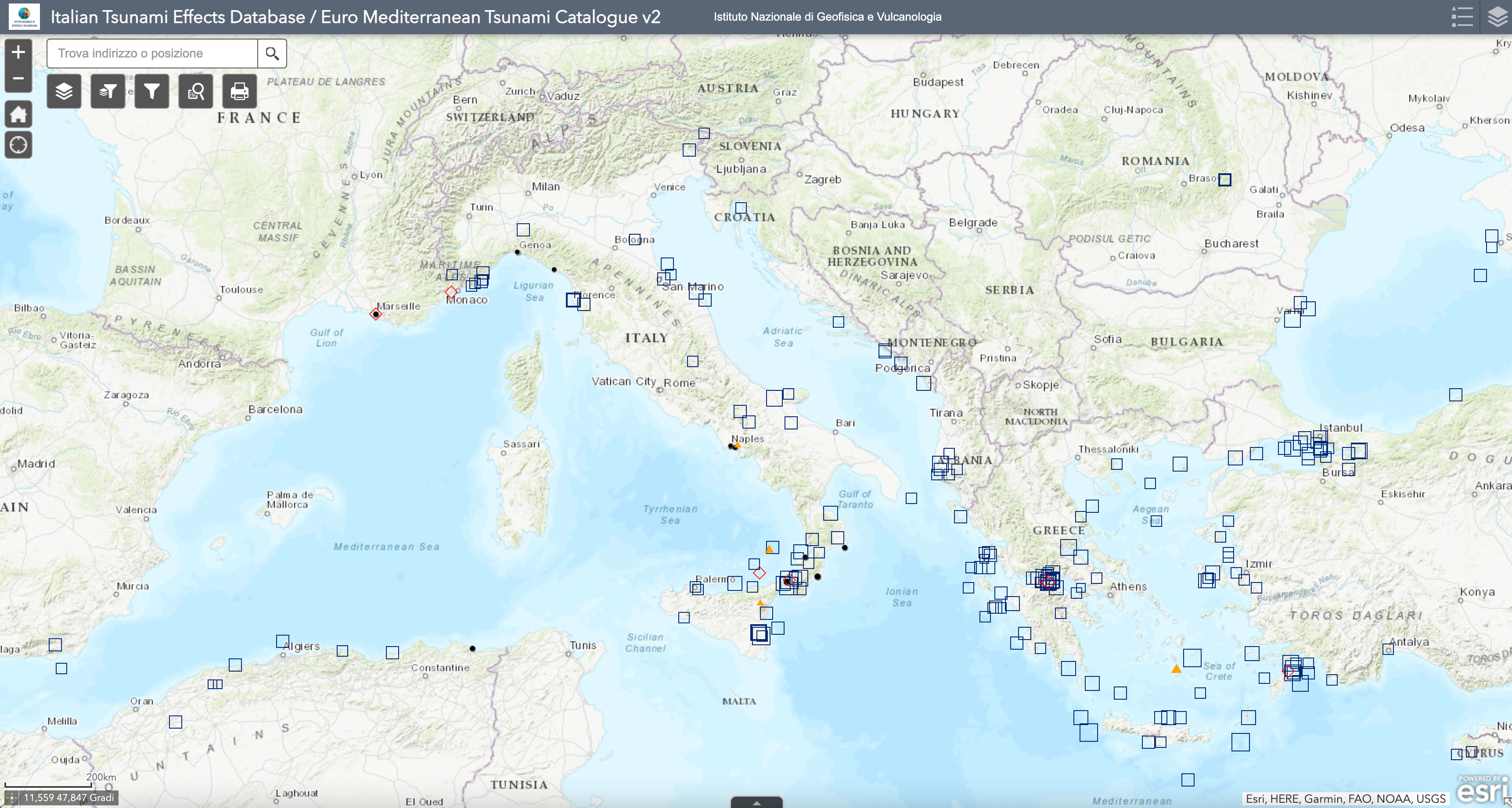
You may access EMTC via its map-based application at the following address
https://ingv.maps.arcgis.com/apps/webappviewer/index.html?id=a14231712588470ea1c4454301b8294c&showLayers=EMTC%202.0
Alternatively, it is possible to obtain EMTC v2 via the following web services:
-
-
- OGC WFS, Open Geospatial Consortium Web Feature Service
https://services.tsunamidata.org/ITED-EMTC/ows?service=WFS&request=GetCapabilities
- OGC WMS, Open Geospatial Consortium Web Map Service
https://services.tsunamidata.org/ITED-EMTC/ows?service=WMS&request=GetCapabilities
- Data Citation
- OGC WFS, Open Geospatial Consortium Web Feature Service
-
Maramai A., Graziani L., and Brizuela B. (2019). Euro-Mediterranean Tsunami Catalogue (EMTC), version 2.0. Istituto Nazionale di Geofisica e Vulcanologia (INGV). https://doi.org/10.13127/tsunami/emtc.2.0
Other Versions -
-
References
Data License
Attribution 4.0 International (CC BY 4.0)
Disclaimer
The EMTC is open to later additions and improvements. For these reasons and due to its intrinsic nature, the EMTC cannot be guaranteed to be complete, accurate and updated in any part, and will be subjected to successive revisions. Although the Istituto Nazionale di Geofisica e Vulcanologia makes every effort to supply the best available information, no warranty, expressed or implied, is provided as to the accuracy and reliability of all the data supplied in the EMTC. Users are cautioned to consider carefully the nature of the data and information before using it for decisions that concern personal or public safety. Conclusions drawn from the EMTC, or actions undertaken on the basis of its contents, are the sole responsibility of the user.
For any question or comments please contact the authors.